SEVERE WEATHER BULLETIN #13
FOR: TROPICAL STORM "#AuringPH" (DUJUAN)
TROPICAL CYCLONE: WARNING
ISSUED AT 5:00 AM, 21 February 2021
(Valid for broadcast until the next bulletin to be issued at 8 AM today)
TROPICAL STORM "AURING" MAINTAINS STRENGTH AND IS NOW MOVING TOWARDS THE WEST-NORTHWEST.
Hazards affecting land areas:
Heavy Rainfall:
• Today (21 February): Moderate to heavy rains over Eastern Samar, Dinagat Islands, Surigao del Norte, and Surigao del Sur. Light to moderate with at times heavy rains over Bicol Region, MIMAROPA, Northern Mindanao, Zamboanga Peninsula, Quezon, and the rest of Visayas and Caraga.
• Tomorrow (22 February): Light to moderate with at times heavy rains over Bicol Region, MIMAROPA, Western Visayas, Northern Samar, Samar, Eastern Samar, Quezon, Aurora, Isabela, and Cagayan.
• Under these conditions, isolated to scattered flooding (including flash floods) and rain-induced landslides are likely during heavy or prolonged rainfall especially in areas that are highly or very highly susceptible to these hazards as identified in hazard maps. Adjacent or nearby areas may also experience flooding in the absence of such rainfall occurrence due to surface runoff or swelling of river channels. PAGASA Regional Services Divisions may issue local thunderstorm/rainfall advisories and heavy rainfall warnings while the Hydrometeorology Division and River Basin Flood Forecasting and Warning Centers may issue General Flood Advisories and Basin Flood Bulletins as appropriate.
Strong Winds:
• In the next 24 hours, the combined effects of the surge of the Northeast Monsoon and Tropical Storm “AURING” will bring gale-force winds in areas under Tropical Cyclone Wind Signal (TCWS) #2 and strong breeze to near-gale conditions with occasionally higher gusts over the areas where TCWS #1 is in effect, as well as over CALABARZON, MIMAROPA, Aurora, and the rest of Visayas and Bicol Region.
Hazards affecting coastal waters:
• In the next 24 hours, rough to very rough seas will be experienced over the seaboards of areas under TCWS (2.6 to 5.0 m) and the eastern seaboard of Luzon not under TCWS (2.6 to 4.5 m). Rough seas (2.5 to 4.0 m) will prevail over the southern seaboard of Luzon (including the eastern seaboard of Palawan), the remaining seaboards of Visayas, and the northern, eastern, and western seaboards of Mindanao that are not under any TCWS. Sea travel is risky for all types of sea vessels over these waters.
• Moderate to rough seas (1.2 to 3.0 m) will be experienced over the remaining seaboards of the country. Mariners of small seacrafts are advised to take precautionary measures when venturing out to sea. Inexperienced mariners should avoid navigating in these conditions.
Track and intensity outlook:
• Tropical Storm “AURING” is forecast to continue moving generally west-northwestward to northwestward in the next 48 hours, with short-term erratic movement still likely prior to landfall. On the forecast track and its probability cone, this storm may initially make landfall over the Dinagat Islands-Eastern Samar (southern portion including Homonhon Island)-Leyte area between tonight or tomorrow early morning.
• There is an increasing likelihood that “AURING” will weaken into a tropical depression before it makes landfall due to persistent high vertical wind shear associated with the surge of the Northeast Monsoon. However, the possibility that the storm will maintain its strength until landfall is not yet ruled out. Post-landfall, “AURING” is forecast to weaken considerably due to significant terrain interaction and the increasing wind shear, leading to deterioration into a remnant low within 48 hours, possibly sooner.
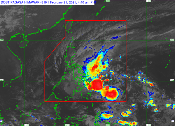
Location of eye/center: At 4:00 AM today, the center of Tropical Storm "AURING" was estimated based on all available data at 395 km East of Hinatuan, Surigao del Sur (8.2°N, 129.9°E).
Strength: Maximum sustained winds of 65 km/h near the center and gustiness of up to 80 km/h.
Movement: Moving West Northwestward at 15 km/h.
Forecast Positions
• 24 Hour (Tomorrow morning): 60 km East Southeast of Guiuan, Eastern Samar (10.8°N, 126.2°E)
• 48 Hour (Tuesday morning):30 km West Southwest of Romblon, Romblon (12.5°N, 122.0°E)
TROPICAL CYCLONE WIND SIGNAL
TCWS #2 (61-120 km/h winds prevailing or expected in 24 hours)
Visayas
The southern portion of Eastern Samar (San Julian, Borongan City, Maydolong, Balangkayan, Balangiga, Lawaan, Llorente, Hernani, General Macarthur, Quinapondan, Giporlos, Salcedo, Mercedes, Guiuan)
Mindanao
Dinagat Islands and the northern portion of Surigao del Norte (Surigao City, Sison, Tagana-An, Placer, San Francisco) including Siargao and Bucas Grande Islands
TCWS #1 (30-60 km/h winds prevailing or expected in 36 hours)
Luzon
Sorsogon, mainland Masbate, and Ticao Island
Visayas
Northern Samar, the rest of Eastern Samar, Samar, Biliran, Leyte, Southern Leyte, Cebu, Bohol, Siquijor, Negros Oriental, the northern and central portions of Negros Occidental (Kabankalan City, Himamaylan City, Binalbagan, Isabela, Moises Padilla, Hinigaran, La Castellana, Pontevedra, San Enrique, La Carlota City, Pulupandan, Valladolid, Bago City, Murcia, Bacolod City, Talisay City, Silay City, Enrique B. Magalona, Victorias City, Manapla, Cadiz City, Sagay City, Escalante City, Toboso, Calatrava, San Carlos City, Salvador Benedicto), the eastern portion of Iloilo (Barotac Viejo, Lemery, San Rafael, Sara, Ajuy, Concepcion, San Dionisio, Batad, Estancia, Balasan, Carles), and the eastern portion of Capiz (Dumarao, Cuartero, Ma-Ayon, Pontevedra, Panay, President Roxas, Pilar)
Mindanao
The rest of Surigao del Norte, Surigao del Sur, Agusan del Norte, Agusan del Sur, Davao Oriental, Davao de Oro, Davao del Norte, Davao City, Camiguin, Misamis Oriental, and Bukidnon
The public and the disaster risk reduction and management council concerned are advised to take appropriate actions and watch for the next Severe Weather Bulletin to be issued at 8 AM today.


No comments:
Post a Comment